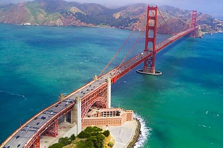
Log in
Email
Password
Register
Menu
Explore
Newest photos
Popular photos
Contribute
Submission guidelines
Photographer signup
Photographer login
About
About Freerange
Image license
API
Contact us
Support
Contact support
FAQ
Login
Login
Register
Search all
Photos
Illustrations
Match All
Match Photo ID
Newest
Popular
Select Category
AI Generated
CC0 Images
Editorial and News
Animals & Insects
Architecture
Architectural Details
Arts & Music
Backgrounds & Textures
Cities and Modern Life
Business & Office
Flowers and Plants
France
Food & Drink
Holidays & Occasions
Health and Fitness
Landmarks
Interiors
Illustrations
Industry & Agriculture
Landscapes & Nature
Letters and Numbers
Objects
Other
Military
People
Signs & Symbols
Sky and Clouds
Space
Sports & Recreation
Technology
Wallpapers
Free Stock Images
Sponsored images from iStock
View footage results
Click to save 15% sitewide with code
FREERANGE15
View More
151 free cities photos from Freerange
Filter results
Popular
Most Viewed
Newest Photos
All licenses
Freerange
CC0
Photos & Illustrations
Photos
Illustrations
Per Page
25
50
100
Map of Israel with Greece and Turkey
Close up of map of Israel with Greece and Turkey with names of cities and states
Colorful South African continent with major cities labeled.
The globe image highlights Africa with a focus on South Africa, displaying a colorful representation of national boundaries, names of countries, major cities, and surrounding regions.
Cloud Computing and Cloud Technology - With Copyspace
Detailed North American region with state and city names.
This image of a globe pinpoints North America, detailing the United States with state boundaries, and includes Canadian regions and cities, emphasizing a detailed cartographic view.
Satellite Image of Australia at Night
The satellite captures Australia at night, showcasing the illuminated urban areas and highways stretching across the vast continent. Cities glow brightly amidst the darkness, highlighting the countrys population centers and infrastructure.
US Capitol Dome
The dome of the US capitol building.
The Earth From Space at Night
The Earth is seen from space at night, illuminated by city lights and natural phenomena like auroras. The continents, oceans, and clouds are visible, creating a stunning view of our planets activity and beauty.
USA Map (East Coast)
Close up of east coast USA Map with names of cities and states
Cloud Computing and Cloud Technology
Earths City Lights Seen From Space
The bright city lights on Earths surface as seen from outer space at night. The continents are outlined by the illuminated clusters of urban areas, showcasing human activity on the planet.
USA Map with names of states and cities
Close up of United States of America Map
Detailed World Map on Dark Green Background
A detailed world map displayed over a dark green background, showcasing continents, countries, and oceans in clear contrast. The map is informative and easy to read, providing a comprehensive view of global geography.
Earth in Darkness
The Earth is seen from space, shrouded in darkness as the sun sets on one side of the planet. The lights of cities and towns are visible, along with natural features like oceans and continents.
United States Capitol Building Straight View
Looking at front of the US Capitol building and dome.
USA Map (West Coast)
Close up of west coast USA Map with names of cities and states
Aerial View of Building With Green Roof
An overhead perspective of a building with a vibrant green roof, standing out against the surrounding urban landscape. The roof is covered in lush vegetation, providing environmental benefits and a visually striking contrast.
Night Map of the United States
This image displays a map of the United States at night, showcasing the distribution of lights across the country. Urban areas are brightly illuminated, while rural regions appear mostly dark.
United States of America (USA Map)
Close up of USA map with names of cities
Old map of Malaysia
Close up of map of Malaysia with names of states and cities
India Map
India Map
Breathtaking view of Earth from space showing the glowing cities.
This image provides a breathtaking view of Earth s curvature from space, showcasing glowing cities scattered across the planet s surface. The illuminated urban areas contrast beautifully against the dark expanse of space, highlighting humanity s presence and technological advancements.
Steps to the US Capitol
US Capitol building in Washington D.C.
Paris in Black and White
Aerial View of Paris with roads and buildings as Eiffel Tower in the background
Cuba Map
Close up of map of Cuba with names of states and cities
Couple sitting on bridge railing overlooking river water
A couple sitting on the railing of a bridge overlook a calm river, framed by historic buildings in a picturesque setting reminiscent of romantic European river cities.
Colonel Hans Christian Heg Statue
Statue of Colonel Hans Christian Heg in front of entrance to Wisconsin State Capitol. The State Capitol building located in downtown Madison was completed in 1917. In 1990, a state law passed to prohibits any building within one mile of the capitol to be taller than the columns surrounding the dome. Today, the current capitol building is the tallest building in the whole of Madison. The beautiful building was designated a National Historic Landmark in 2001.
Monochrome skyscraper towering over city
A black and white photo capturing the towering presence of an iconic skyscraper amidst surrounding buildings
Modern bridge structure extending over a wide river
A stunning architectural feat a modern bridge with strong supporting pillars extending over a wide river, joining cities and facilitating transportation, representing connection.
European regions highlighted showing France and Spain.
The globe image zooms in on European regions with a focus on France, Spain, and neighboring countries, showing city names, visible boundaries, and detailed cartographic style.
Detailed vintage map focusing on Iceland s geographical outline.
A highly detailed, close-up view of a vintage globe highlighting Iceland s geographical outlines, cities, and major landforms, showcasing its unique location in the North Atlantic.
Map of the United States on a Table
A detailed map of the United States is spread out on a wooden table. The map shows all 50 states with their boundaries clearly defined.
Vehicles on highway
Vehicles on highway on a cloudy day
Map focus on Middle Eastern and European regions.
The globe features a detailed look at Middle Eastern and European regions, highlighting countries such as Turkey, Saudi Arabia, and surrounding territories, showing city names and boundaries.
United States of America USA Map
Close up of USA map with names of cities and states
China Map
Close up of map of China with names of cities and states
Looking Up at Tall Buildings in Urban Landscape
The view from below shows towering skyscrapers against the sky, emphasizing the scale and height of the buildings in the urban environment.
Direction Signs With Arrows
Close up of colorful wooden direction signpost with destination cities
Old Map of Hudson Bay
Close up of map of Hudson Bay with names of cities and states
Map showing Soviet Socialist regions and boundaries.
This image displays a detailed close-up view of a historical globe, focusing on regions described as Soviet Socialist territories with visible national boundaries and city names.
Vintage globe map of Sweden and surrounding countries close-up.
Close-up view of a vintage globe highlighting Sweden and its neighboring countries, focusing on geographical boundaries and major cities with historic relevance.
Overview Japan Cities at Night
Cities in Japan
Atlanta Skyline At Night
Atlanta skyline at night.
Australia Map
Close up of map of Australia with names of cities and states
Skyscrapers - Philadelphia, Pennsylvania
Night View of Skyscrapers with red and pink sky in Philadelphia, Pennsylvania
Old map of Saudi Arabia
Close up of map of Saudi Arabia with names of cities and states
Old Map of Madagascar
Close up of map of Madagascar with names of cities and states
Map of Japan
Close up of Japan map with names of cities and states
Russia Map
Close up of map of Russia with names of cities and states
Car Driving Down Road at Night
A car with its headlights on is seen driving down a dark road at night. The road is illuminated by the cars lights and stretches into the distance. The surroundings are enveloped in darkness with only the road visible.
Alaska highlighted on a globe along with surrounding areas.
This image focuses on Alaska as highlighted on a globe, showing its location, cities such as Fairbanks and Anchorage, and neighboring Canadian regions, emphasizing detailed cartography.
Find even more royalty free stock photos from the world's best photographers
View
of
4
Try your search on iStock: