Log in
Email
Password
Register
Menu
Explore
Newest photos
Popular photos
Contribute
Submission guidelines
Photographer signup
Photographer login
About
About Freerange
Image license
API
Contact us
Support
Contact support
FAQ
Login
Login
Register
Search all
Photos
Illustrations
Match All
Match Photo ID
Newest
Popular
Select Category
AI Generated
CC0 Images
Editorial and News
Animals & Insects
Architecture
Architectural Details
Arts & Music
Backgrounds & Textures
Cities and Modern Life
Business & Office
Flowers and Plants
France
Food & Drink
Holidays & Occasions
Health and Fitness
Landmarks
Interiors
Illustrations
Industry & Agriculture
Landscapes & Nature
Letters and Numbers
Objects
Other
Military
People
Signs & Symbols
Sky and Clouds
Space
Sports & Recreation
Technology
Wallpapers
Free Stock Images
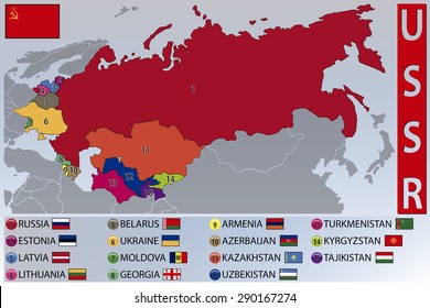
Map showing Soviet Socialist regions and boundaries.
This image displays a detailed close-up view of a historical globe, focusing on regions described as Soviet Socialist territories with visible national boundaries and city names.
Download options:
testing
Share
Full size image
3500 x 2336 - 0.47mb
Medium - Social media size
970 x 647 - 0.04mb
Small - Blog size
640 x 427 - 0.03mb
Send to PIXLR to edit
Image will load in PIXLR
Login to Download
Login to Download
Need to Register?
Photographer:
World Maps
17 images
Categories:
CC0 Images
Keywords:
(click to search)
Historical
History
Landscape
map
Retro
russia
USSR
boundaries
cartographers craft
cartography
cities
detailed
earth
eastern europe
education
exploration
geography
global studies
globe
grid lines
historic globe
kazakhstan
knowledge
lens focus
travel
sphere
direction
topography
concept
journey
compass
planet
searching
world
discovery
explore
geographic
close up
mid20th century
nostalgia
politics
precision
regions
representation
science
socialist
soviet
soviet era
soviet union
study
uzbekistan
vintage
zoomedin
Show all keywords
Sponsored images from Shutterstock
View footage results
Click to save 15% sitewide with code
FREERANGE15OFF
View More
Comments:
View all 0 comments
Try your search on Shutterstock:


Comments:
View all 0 comments